Tag Archives: Final Project

Project Update: YouMap Experimentation 1

So for this week, it was all about experimenting and trying to see how it flows.

The objective was to be able to consciousness focus on the google map to navigate myself to a destination without paying attention to my surroundings visually.

Previously, I had already experimented in school with regard to the way it was to be captured.

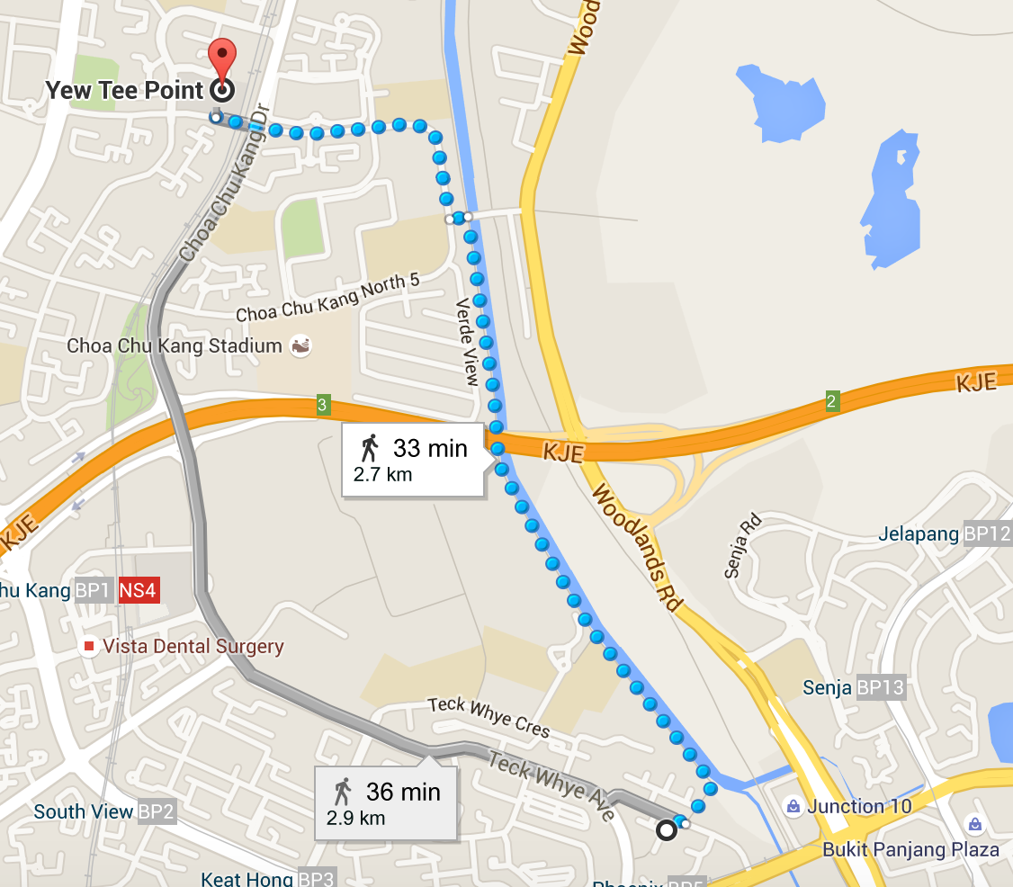
Initially, I planned to do it on Wednesday after getting all my equipment and testing them out. I planned to go from my house to Yew Tee Point, which I also proposed the last time. However, due to the rain, I had to postpone the whole experiment today.

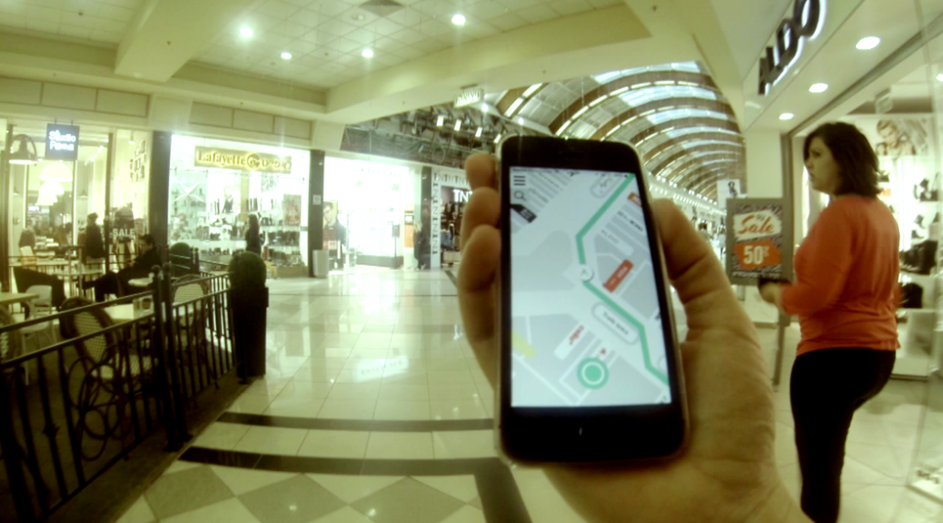
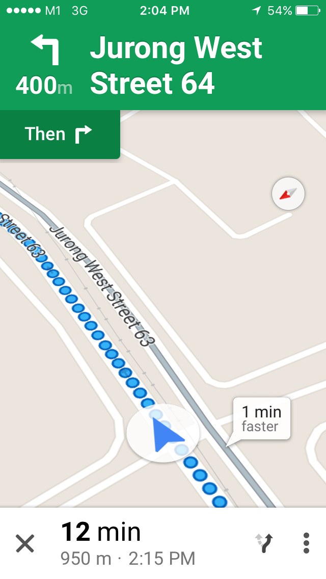
I started from Pioneer Mrt Station and decided to navigate myself to Jurong Point. It was to take me approxmiately 20 to 30 minutes to reach there. Hence, I commenced with the journey, being very conscious mostly to focusing on the Google Map and not what’s infront of me visually.

Google Start

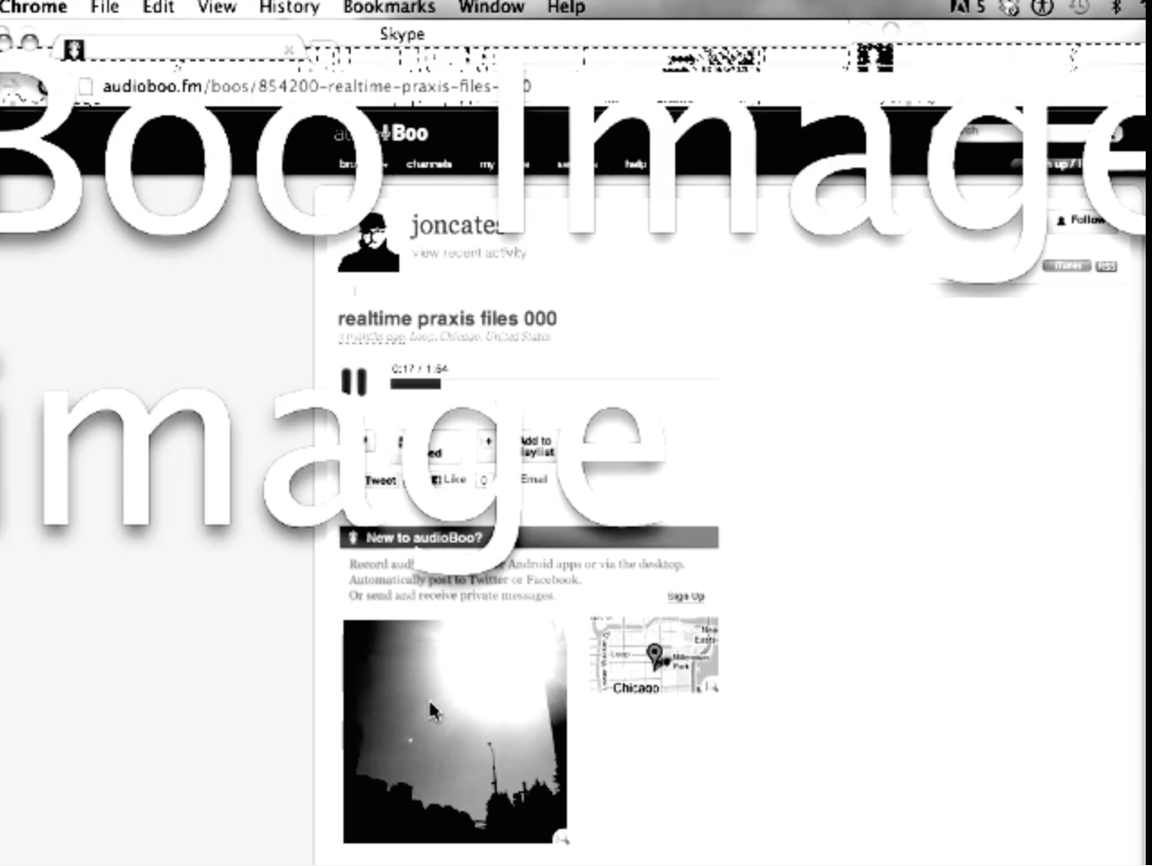
I used a samsung phone to record my voice while using my iphone to navigate through to Jurong Point Mall. I took screenshots of the Google Map as I navigated to the Mall. Thus, I have used the voice recording together with the screenshots to create a short clip of my process. I could update the whole 21 mins recording due to space constrains.

The overall experience with having to navigate using Google Maps alone and trying to consciously focus on it visually can be both tiring and scary. I tend to lean on my sense of hearing for me to be cautious about my surroundings. When I am nearing a traffic light ( which I use Google Maps to detect when I have to cross a lane), I tend to automatically survey my surroundings immediately and to make sure that I am able to cross the street.

Google Middle

As a person who loves to talk, I found myself many times repeating my descriptions of the surrounding or my emotions. It got to a point where I just had to leave it silent. The recording became too mundane, in my opinion. I left it didn’t truly express me as I was a visual person.

Google Cross Road

Along the process, listening to my surroundings became extremely keen to accommodate my sense of security. The beginning stage, where the surrounding sounds just included children, buses etc, the sense of security was at bay. However, as mentioned in my recordings, it became worse as I approached the Mall. The sound was heavy, and had constant overlaps. This created discomfort in me. I was getting very frustrated and this overwhelming sense of discomfort that most probably I associated with danger. It was then, that I was more interested in ending the whole process. It was a sense of urgency and despair that filled me.

The idea of using the virtual realism to dominate my physical boundaries seemed possible when the environment was as peaceful as what it was in the google maps. However, when the scenario changes, there are certain natural instincts that I tended to express. I wouldn’t pin it down as a fight or a flight theory but it runs along those lines.

Google Next

So what’s next?  I analysed today’s project and realized that, as mentioned during last week’s critique, I needed to record myself in the process- which is essential.  However, by planning the location and the route, I think I put myself on familiar grounds and hence was confident to do it. Such familiarity was strong that I didn’t have much to talk about or express my feelings.

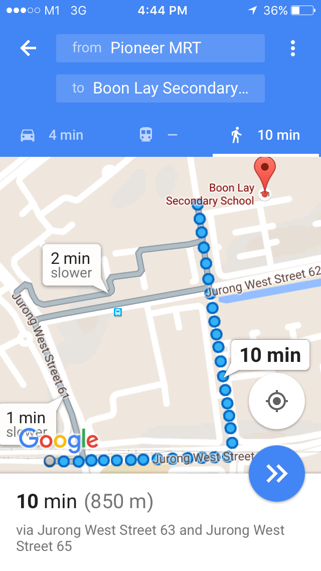
Hence, the next recording I am intending to do is to walk from Pioneer Mrt to Boon Lay Secondary School. Boon Lay Secondary School was secondary school. The paths to the school are filled with memories and I hoping that I can recapture those through my Google Navigation. Perhaps, this time, I will take a video from my perspective, navigating yet going down ‘memory lane’.


Project Hyperessay #1: Concept

The project aims to reflect on the dependency of technology to ‘navigate’ our lives, literally. Instead of the usual scenario of the physical world being simulated to create virtual world like in Google Maps ( where the map is a representation of the physical world), we use the virtual space to experience the physical world through navigation.

My process for conceptualization sparks with my research into the different readings, critiques and micro-projects respectively.

The concept was ignited and influenced by Brian Whitworth’s Research Report, an exploration in concept that the physical world is construed as a virtual world and in it the universe is grounded by digital processing and information.

“Things constituted the same way are substantial to each other, so likewise what is “real” depends upon the world it is measured from. To say a world is a virtual doesn’t imply it is unreal to its inhabitants, only that its reality is “local” to that world, i.e. not an objective reality.”

By  comparing the definition of ‘reality’ and ‘unreal’, Whitword calibrates the two worlds based on our perception of reality and how those measurements create the differentiation between the worlds.

Sensorama-Advert

Morton Heilig’s 1.5million dollar machine (1957)

The ideas such as universality and choice creation are the ground factors that I partially took to conceptualize. However, I needed to ground this physical-virtual universe to myself in order to immerse into the experience and to grasp the first person perspective. I looked for inspiration at Jon Cates’ Bold3RRR, where there is the constant flipping between Jon Cates and his desktop screen.

Jon Cates

Jon Cates 2

This motion made reflect on the idea of identity, where you represent yourself in the physical world but your actions are represented in the virtual world. On the other hand, Jennicam by Jennifer Ringley is bridges the two aspects where she puts herself and her partial life in the internet for anyone and everyone to access. She allows her physical identity and actions to be represented as her virtual identity and actions, in parallel.

Jennicam

https://www.youtube.com/watch?v=khZILGJXOGc

In short, I use Steve Dixon’s ‘Webcams: Subversion of Surveillanceterm to coin this as ‘documentary realism’ and to understand this as an art form. To quote Steve Dixon, “Liveness and actuality are the ontological conjoined-twins of the webcam and this inextricably links the new webcam medium to the liveness and accuality of performance art”, reminding us how we are able to the fundamental elements that add impact to a reality broadcast. 

However, the physical world is not as static as the shape of our computer screen as portrayed in both Cates and Ringley’s projects. Taking reference from the two attempts I had for my micro-project using the phone application ‘Periscope’,

I realized that the virtual space primarily consist of connectivity with people everywhere around the world. If I wanted to construct a virtual-physical world, I needed to add the element of broadcast with connectivity and mobility. Periscope allowed you to gather information about another location and atmosphere through the perspective of another person. You often are guided through these perspectives and opinions either real-life or at least current.

Gluing the idea of documentary realism together with mobility, connectivity and broadcast, I reflect on our dependency on technology and how we operate or navigate our life using them. Thus, to take the term ‘navigate’ literally and to challenge technology’s position in the physical world would be the artistic objective I aim to achieve. My belief in self indulgence and self reflection, through Jennicam and Bold3RRR, aims to explore this objective through my own perspective and to avoid the multiple participation yet, it applies to the majority of the viewers for self-reflection with regard to our daily use of technology.

Hence, to accomplish my objective, I decided that I would use Google Maps to navigate my path around a particular unfamiliar location without depending on the elements of the physical world such as signage or directive aids. To create a connection to the viewer, I would take a video selfie of myself while navigating solely on Google Maps. I am planning of doing it from my house area to Yew Tee Point. Conducting this project during peak hours ( joggers, walkers doing their daily exercises) creates a natural environment without compromising safety ( where the areas near the road can be quite dangerous and disruptive since I am concentrating on my smartphone).Google Maps to Yew Tee

This is create a connection to the audiences like what Cates and Ringley had done through their projects. At the end of the journey, I will take time to reflect my feelings to add an emotional factor that once again drives self-reflection among my audiences.

In conclusion, the project would illustrate the detachment of the physical world and our disconnection with the physical surroundings when we are so tuned into the virtual world. By my dependency on Google maps to navigate through my own physical word, I am demonstrating the power of mobility with regard to virtuality yet ironically, it becomes a catastrophe when we are losing our natural state ( interaction, listening, observing etc).