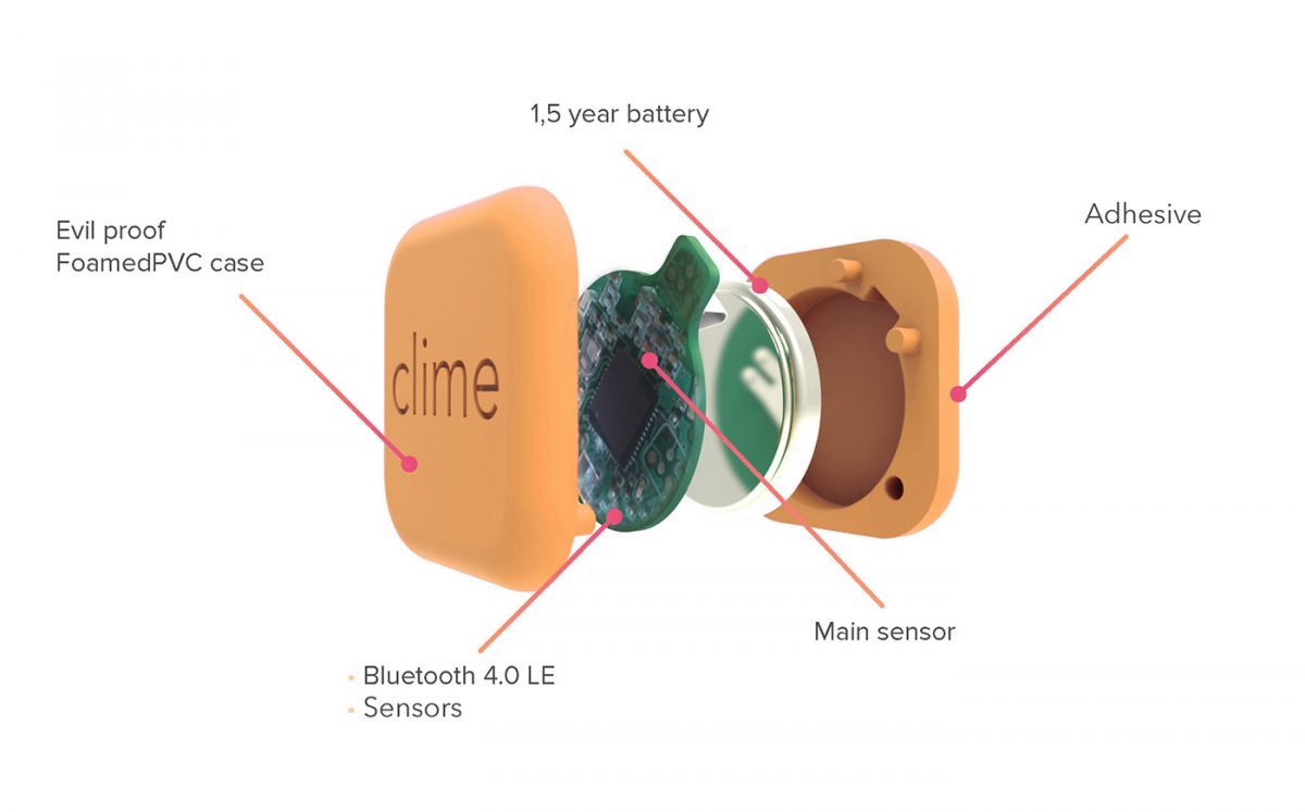
Clime is a small thing with multiple sensors inside it self, the sensors can feel temperature, movement, humidity and light. This gives the thing multiple areas of use for example exotic animals and herbs!
1 of

Clime is a small thing with multiple sensors inside it self, the sensors can feel temperature, movement, humidity and light. This gives the thing multiple areas of use for example exotic animals and herbs!
Maps are often used by people to contextualise their surroundings when they might want to get from one place to another, understand topology or maybe study geography. Maps are interpreted different by the person using it, some imagine them self in the map as a 3D-model, some try to imagine what it will look like when they arrive other people might just try to memorise the name of the street.
I think people already use different emotions to map their surroundings. Feelings are triggered by the environment we’re moving through can still give us a clue about where we are going.
I was once in Rio de Janeiro and on beforehand I had studied the map of the area where I was about to stay. I knew that I had to get of the bus at a certain place where I could see the sea and then walk the rest of the way with the sea in my back to the place where I was about to stay. The area where I was about to stay was an okey are which means that you should know where you are going to not end up in trouble, the trouble is hard to spot on the map, but you can as a human feel the surroundings thorugh the impact on your perception of the environment. In this case when street-lightning start to disappear and streets become more narrow you can feel that you might not have the control of the situation that you want. Even though you might not be in any danger at all, its just your prejudices which’s telling you this, it can give you a clue that you might have walked to far off and it’s time to turn around.
I think maps can be made with other main orientation tools such as roads, crossings and streets. As mentioned just above, you can map the feeling of an area, how the certain place sounds like, what smells is there, the people, sidewalk activities and so on. One thing to keep in mind here is that people use different senses. Some rely more on smell when others rely on hearing and others merge these senses in to get a feeling. Some people just use their eyes and build a map inside of their head with reoccurring signs like restaurants and cafés to know that they’ve been there before and next time they probably should be going right instead of left.
Talk. One way to find a way through the city is to ask the people living there, an art that might has been forgotten when smartphones and maps always knows the fastest way through the city.
Smell. Another way could be to map the smells of the city. For example, in chinatown and little india you can feel the smell of cigarettes much more often and the smell of a certain dish could make you go right or left.
Sound. Sounds is a convenient way to guide you through the city, sounds that are significant and reoccurring can work well when it comes to find the way. I’ve used it by my self a lot of times when I tried to find a concert or maybe home from the forest
Crowds. In big cities like Singapore where you don’t necessarily have to fight for your survival crowds can be a good to orientate in the city, during the morning hours commuters move towards the MRT system, and by following the majority of the people they will probably get you there, if it’s what you desires. Crowds can be used to know that you are in a popular area and close to a good area with nice bars and restaurants.
Conclusion. Of course you could follow more old school tricks like stars, birds, cloud formations and the sun. But in these days with the haze, climate change, light pollution and so on these old tools for navigation is hard, so it might be easier to follow the crowd, listen for the particular sound clue, smell or a person to ask. In the future, where we to 45% operates in this course, we will absolutely have other ways to navigate than maps. Maybe through vibrations, sounds and maybe even by emotions triggered by our futuristic phones.
I think that the subject ‘sidewalks’ is really interesting, especially because it’s from there you encounter the city and most probably where you get impressions and create memories. The meaning of sharing the sidewalk both in a direct way between us people and sharing it when it comes to a wider context such as in economic growth and progress, and to whom the sidewalk belongs to after the change has taken place is interesting. Who should we develop the sidewalk for, how should we design it? Is it for the most efficient transport of people, workers, with wide esplanades? Or is it for the sellers standing there to make their business go round? Both these interest could might go along side by side, but I can see that these two interest are competing with each other, that cities and communities whom striving towards economic growth and a more westernized lifestyle turn away from this and letting their streets belong to famous coffee companies and fast food restaurants. In a way this might be the natural way of development, which later will turn in to the search for what the particular society came from. Such as we can see now in Sweden for example where small cafés, food-trucks, street sellers, alternative restaurants reclaims more of the cityscape, streets and sidewalks in some kind of search for the genuine experience of the future of the past.
I think you, as a designer, has to consider the identity of a street, the people walking there everyday, the people working there and the people just passing by. As it was mentioned in the text, the research of a designer has to be connected to the reality through the citizen who are the user. I like the idea of the SEED network because it doesn’t matter how many prizes it has won when the human who lives, works or passing by there can’t use it.
This is just thoughts I got while reading the text, it’s easy to be caught up by small things when you write about possibilities and problems like this and you end up might missing the bigger context. Anyway, I really enjoyed the text.
How will the increasing effectiveness of our production change the cityscape and sidewalks, when automated robots and computers will do more of our work and everyday commuters might not have to go to geographically bound work?
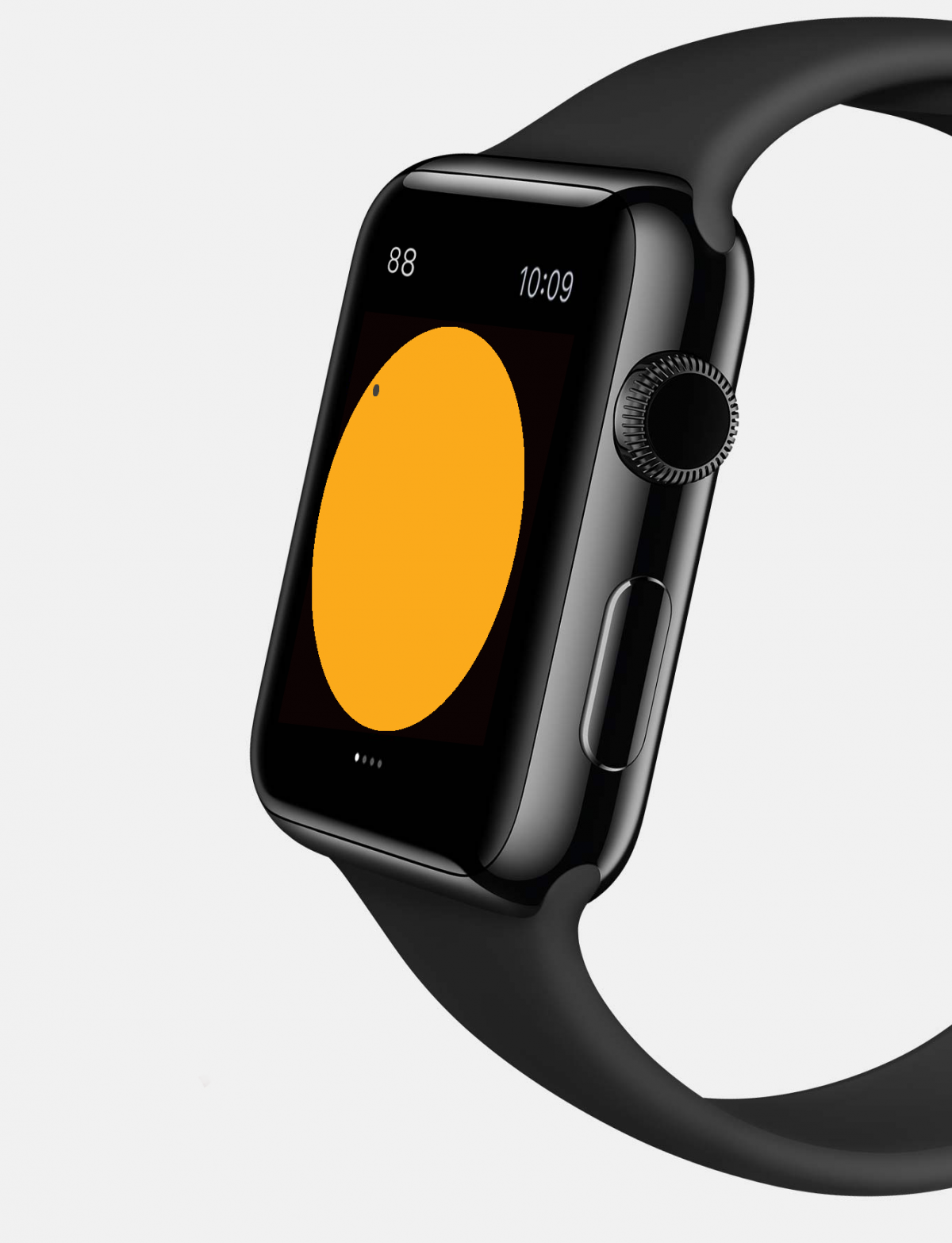
This project was made in the course Design – Build – Test. The project was to make an application for Apple Watch which would interact with a speaker so that the user could control the music, source and sound etc. from the clock it self. Might not be the most interactive with no automated smartness, but still.
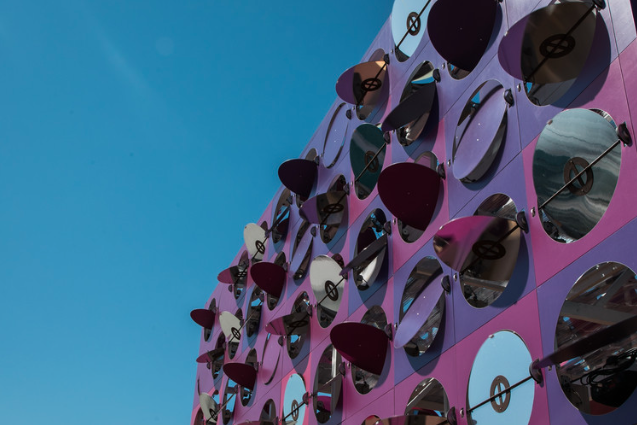
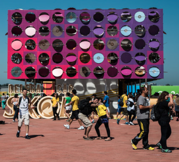
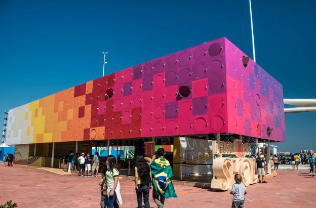
The Dancing Pavilion is an interactive house built for the Rio Olympics. The floor inside the house has been equipped with sensors that sense hove the people inside move, and sensors that also senses the music that are being played. The walls of the house consists of circular shapes with mirrors on one side, and different colours on the other side. These discs move in correlation with the music and people inside the house, the result can be seen from inside or outside.

It’s hard to ride an escalator, it’s harder break through a crowd.
Helo,
Doing this for the sake of my future.